|
| |
 The current village of Stonegate in East Sussex was located at
the cross roads of two old Roman roads, one
linking Pevensey with the inland hills, and the
other linking Bardown(an old Roman iron works to
the north of the village), with the sea possibly
at Etchingham or Salehurst . The current village of Stonegate in East Sussex was located at
the cross roads of two old Roman roads, one
linking Pevensey with the inland hills, and the
other linking Bardown(an old Roman iron works to
the north of the village), with the sea possibly
at Etchingham or Salehurst .
Once the Romans had left, the area returned to its
rural existance. After the Norman invasion it
became part of the Robertsbridge Abbey lands, and
on its dissolution in 1539 by Henry VIII, its
ownership was transferred to the Sidney family.
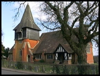
In 1836, Stonegate became a district in its own
right and the small village was given a church in
1838. This was demolished in the early 1900's due
to bad workmanship, and a new one built in 1904.
1851 saw the railway build from Tunbridge Wells ,
this was originally known as Witheringden, after
the mill on the Rother valley. Next it became
Ticehurst Road, as it was the nearest station to
the large settlement of Ticehurst , finally it
became known as Stonegate . |
|
 Stonegate in East Sussex is towards the top of a hill, with one
of its best views from a point just South of the
station across the Rother Valley towards Burwash Weald . Stonegate in East Sussex is towards the top of a hill, with one
of its best views from a point just South of the
station across the Rother Valley towards Burwash Weald . |
|
 Stonegate in East Sussex has very few services as it is only a
small village.
The London to Hastings railway service stops at
Stonegate station, but this is about 1 mile from
the village. The service provides a 1 hour 5
minute journey to Cannon Street and Charing Cross. Stonegate in East Sussex has very few services as it is only a
small village.
The London to Hastings railway service stops at
Stonegate station, but this is about 1 mile from
the village. The service provides a 1 hour 5
minute journey to Cannon Street and Charing Cross.
This service runs approximately every 20 minutes
in the rush hour, and hourly in between.
The nearest shopping centre is Wadhurst about 4
miles North West, with the main centres in
Hastings approx 15 miles South East and Tunbridge
Wells about 10 miles North West. |
|
| Stonegate is shown as the red symbol on the map. |
|
|
Nearby Villages
(click on symbol to see the village page) |
| Village= | |
Town= | |
Recorded in Domesday= |  |
| |
|
|
Broad Oak |
(Smallpox at the Academy) | | 5.51 miles |
|
|
Burwash |
(The home of Rudyard Kipling) | | 2.40 miles |
|
|
Burwash Common |
(Roughest pub in the South East) | | 3.72 miles |
|
|
Burwash Weald |
(Roughest pub in the South East) | | 3.52 miles |
|
|
Etchingham |
(The oldest Brass Weather Vane in the country) | | 3.16 miles |
|
|
Flimwell |
(300 local people beheaded) | | 3.36 miles |
|
|
Hawkhurst |
(A Notorious Gang of Smugglers) | | 5.86 miles |
|
|
Hurst Green |
(The Youngest Highwayman on record) | | 4.15 miles |
|
|
Mark Cross |
(Policeman arrests eccentric landowner) | | 5.56 miles |
|
|
Mayfield |
(Saint Dunstan and the Devil) | | 5.09 miles |
|
|
Robertsbridge |
(The Home of Modern Cricket) | | 5.31 miles |
|
|
Salehurst |
(Richard the Lion Heart's Gift) | | 5.71 miles |
|
|
Ticehurst |
(Anne Boleyn and Pashley Manor) | | 1.68 miles |
|
|
Wadhurst |
(Last bare fisted Prize-Fight in England) | | 2.66 miles |
|
|


